


Weather Underground is a hyper-local weather forecasting app that provides precise current conditions and updates from over 250,000 personal weather stations. The app leverages advanced Nexrad radar technology and a proprietary forecast model to deliver accurate microclimate-level weather data. Users can access detailed information such as Doppler radar imagery, temperature updates, wind speed, humidity, and pressure. This level of precision ensures users are always prepared for local weather changes, whether it's extreme rain or unexpected drought.
The app also offers customizable features like light & dark modes, various map types, and units. With its interactive weather maps, users can visualize different weather overlays, satellite imagery, and heat maps. These features make Weather Underground an essential tool for those seeking reliable and localized weather information.
Weather Underground stands out with its sophisticated weather visualizations and interactive maps. The app provides hi-res satellite imagery and cloud cover data powered by NOAA's GOES-16, allowing users to monitor severe weather events closely. Its hurricane tracker and storm radar offer real-time alerts, ensuring users are prepared for extreme weather conditions in their area.
One of the key innovations is its reliance on personal weather stations (PWS) rather than airport weather stations. This approach fills the gaps between traditional data points, offering more accurate neighborhood-level forecasts. Users benefit from real-time rain accumulation, precise pollen forecasts, and temperature readings that reflect their immediate surroundings. Additionally, premium subscribers can access Smart Forecasts and extended hourly forecasts up to 15 days ahead, enhancing planning for outdoor activities.
Weather data accuracy is crucial for making informed daily decisions. Weather Underground ensures precise forecasting through its network of over 250,000 personal weather stations. These stations provide real-time updates specific to microclimates, ensuring users receive the most relevant information for their exact location.
The proprietary forecast model combines hyper-local data with advanced algorithms to deliver reliable predictions. This includes detailed current conditions, hourly and daily forecasts up to 10 days ahead, and specialized alerts from NOAA. Such comprehensive coverage empowers users to prepare effectively for upcoming weather changes.
Users benefit from accurate rain predictions, temperature fluctuations, wind speed, and direction. The app's Nexrad network and Doppler radar technology further enhance reliability by tracking severe weather patterns like hurricanes and storms. With these tools, individuals can trust they are receiving credible and actionable weather data tailored to their environment.
Understanding both the temporal and spatial aspects of weather forecasting is essential for planning outdoor activities. Weather Underground offers extensive forecast ranges that cover immediate and long-term weather conditions. Users can access hourly forecasts for the next 15 days, allowing them to plan events and travel with confidence.
The app provides localized insights using its vast network of personal weather stations. This granular approach ensures that forecasts reflect true microclimate conditions rather than generalized regional predictions. Features such as the air quality index, UV index, sunrise, and sunset times offer additional context for daily planning.
Advanced visualization tools, including interactive maps and hi-res satellite imagery, enable users to explore weather patterns across different terrains and timeframes. By leveraging sophisticated technologies like GOES-16 and NOAA-powered cloud cover imagery, Weather Underground delivers a detailed spatial analysis. This empowers users to anticipate weather shifts accurately and make well-informed decisions based on precise temporal and spatial data.
Hyper-local forecasts
Precise weather data
Interactive maps
Customizable experience
Real-time alerts
Premium subscription cost
Ad-heavy free version
Limited global coverage
Complex interface
Occasional inaccuracies

Moon phase calendar with live wallpaper, lunar widget, & 3D simulation.
 3.60
3.60
Weather for Indiana, Kentucky and Ohio
4.90
Retro TV-style digital watch face with weather, heart rate, steps & events!
4.2
Arrive safely! Travel weather forecasts for your entire trip at time of arrival.
3.60
Live weather radar, widgets & forecasts. Track rain, storms & temperature.
4.20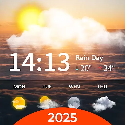
Your Personal Weather Assistant
4.00
Your local weather app with storm radar, rain tracker, weather maps & AQI.
4.5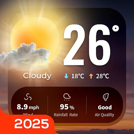
Your Trusted Weather Companion
4.40
Track lightning strikes with our thunderstorms map, radar and lightning alarm.
4.70
The moon phases app for tracking the lunar calendar, blue moon and full moon.
4.80
NOAA forecast & radar for your exact location.
4.80
Ultimate weather forecast + moon phase for Wear OS 5+ (Pixel, Galaxy, et al.)
4.70
Weather radar, satellite, wind, waves, ocean and hurricane forecasts.
4.70
Local forecast, alerts, rain, snow and wind radar, air quality & weather widget
4.60
Get the ad-free version of the highly rated WeatherBug app for accurate weather!
4.50
Weather watch face for Wear OS 5
4.40
Personal Weather Station PRO - Meteo monitor to check your WU info and charts.
4.20
A powerful weather forecast to get real-time weather information
3.60
Most precise & accurate compass app give true North South East West directions.
3.00


User Reviews